
Why Google Maps Got Lost in South Korea
From Kim Jeong-ho’s 1861 master map to Google’s 1:5,000 breakthrough — why a map is never just a map
In this article
- Wait. Google Fought Korea for Almost Twenty Years Over a Map?
- What Exactly Does “1:5,000” Mean?
- And No, Google Maps Did Not Suddenly Become Perfect in Korea on February 27
- South Korea Was Not China
- Drive in Korea Once and You Understand That “Map” and “Navigation” Are Not the Same Product
- Foreign Visitors Learned This the Hard Way
- Google Is Not Fighting for 52 Million Korean Users
- This Is Where “It’s Just a Map” Falls Apart
- Sunlight Is a Map Problem
- So Is the Han River’s Water Level a Map Too?
- And No — Google Did Not Receive All of That
- Why Do Insurance Companies Care About Maps?
- Google Is Already Connecting Maps to Gemini
- Because a Modern Map Is Really a Search Engine for the Physical World
- Did Countries “Give Google Their Maps for Free” and Become Dependent?
- Google Does Not Need to Own a Country’s Map to Own Its Mapping Ecosystem
- “Free” Maps Are Not Always Free
- Europe Is Already Treating Google Maps as Infrastructure, Not Just an App
- And Yes, Money Was Always Hiding Behind Korea’s “National Security” Argument
- Korea Also Gained Something From Keeping Google Out
- It May Also Have Bought Local Companies the Right to Be Lazy
- And Now We Need to Go Back 165 Years
- Kim Jeong-ho Was Thinking About Mobile Maps in 1861
- His Bigger Innovation Was Distribution
- The Most Famous Story About Kim Jeong-ho Is Also Mostly Wrong
- Kim Jeong-ho Was Not a Human Google Street View Car
- And the Government Burned All His Printing Blocks?
- The False Story Was Politically Useful
- Kim Jeong-ho Was Actually Obsessed With Making Geographic Information Useful
- So Would Kim Jeong-ho Have Given Korea’s Map to Google?
- If Google Gets the Map, Google Does Not Get Korea
- Google Does Not Have to Steal the Map
- But Locking the Door Forever Is Not “Map Sovereignty” Either
- South Korea Actually Has Assets Worth Defending
- Korea Is Also a Very Attractive Test Market for Google
- And Korea Does Need Google Too
- This Is Why the 1861 Map and the 2026 Google Decision Belong in the Same Story
- Except Google Has Things Kim Jeong-ho Never Had
- “Why Didn’t Korea Just Give Google the Map?” Is Therefore the Wrong Question
- So Go Back to February 2026
- Kim Jeong-ho’s Myth Gives Us One Final Warning
- If You Want to Attack Google, Attack the Right Thing
- But Korea’s Answer Cannot Be “Stay Out”
- In 1861, Korea Put Dots Every 10 Ri
- Maps No Longer Just Show Where Roads Go
In February 2026, two events happened in South Korea just fifteen days apart.
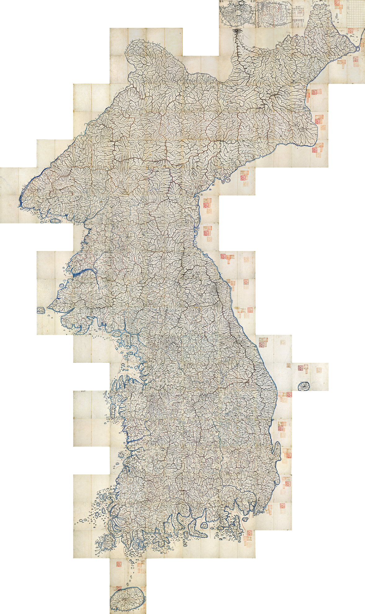
On February 12, the National Museum of Korea unfolded all 22 sections of the Daedongyeojido, the “Great Map of the East Land,” created by the legendary cartographer Kim Jeong-ho in 1861.
Fully assembled, it stretches roughly 6.7 meters high and 3.8 meters wide.
It is enormous.
Mountains ripple across the peninsula. Rivers connect. Roads stretch between towns. Symbols mark government offices, military facilities, postal stations and signal beacons. Small dots along roads help travelers estimate distance.
It is, in effect, a giant nineteenth-century database of Korea.
Then, fifteen days later, on February 27, 2026, the South Korean government made another major map decision.
After nearly twenty years of rejection, it conditionally approved Google’s request to export South Korea’s 1:5,000-scale high-precision map data overseas.
Google had previously asked in 2007.
Rejected.
It tried again in 2016.
Rejected again.
Then, in 2026:
finally approved.
At first, the two stories seem to have nothing to do with each other.
One is about a Joseon-era cartographer using wooden printing blocks.
The other is about one of the most powerful technology companies on Earth.
But they are really asking the same questions.
Who maps a country?
Who controls the map?
Who distributes it?
Who updates it?
And, increasingly:
who makes money from everything built on top of it?
Wait. Google Fought Korea for Almost Twenty Years Over a Map?
That is the first strange thing.
It is 2026.
Satellites can photograph the planet.
You can zoom into North Korea on Google Earth.
Commercial satellite imagery is everywhere.
Road networks can be reconstructed from multiple sources.
Military facilities are not exactly invisible to anyone with enough money and patience.
So why did South Korea care so much about exporting detailed map data?
And perhaps the better question:
If maps are so unimportant now, why did Google keep asking for nearly two decades?
That question takes us somewhere much more interesting.
Because Google does not really want a map.
It wants what maps have become.
What Exactly Does “1:5,000” Mean?
A 1:5,000 map is much more detailed than the coarser mapping data that Google had historically been able to use for Korea.
On a paper map, 1 centimeter represents 50 meters in the real world.
On a 1:25,000 map, the same centimeter represents 250 meters.
But in the digital world, scale is not simply about zooming closer.
Detailed spatial data helps describe how roads actually connect.
Where the entrance is.
Whether two roads that appear close are physically connected.
How an intersection is structured.
Which road belongs to which level of a complicated interchange.
Where a narrow access road begins.
How traffic can realistically flow through the network.
That matters enormously for navigation.
South Korea did not simply hand Google the country’s entire spatial-information system in 2026.
The approval was restricted mainly to base-map and transportation-network data needed for navigation and route guidance.
Sensitive information such as contour data was excluded.
Military and security facilities are subject to masking requirements.
Certain coordinate information is restricted.
Original data must first be processed on servers in South Korea, with government review before approved material can be exported.
Google must maintain personnel and procedures in Korea for security compliance.
In other words, the government did not exactly say:
“Here you go, Google. Take Korea.”
It said something closer to:
“Fine. You may take this part. We are watching.”
And No, Google Maps Did Not Suddenly Become Perfect in Korea on February 27
The approval was important.
But an export license is not the same thing as a finished navigation service.
As of August 2026, Google has still been developing the full Korean navigation experience enabled by the decision.
So the February announcement was not the opening of a completed highway.
It was permission to begin building one.
That distinction matters because foreigners sometimes hear “Korea finally allowed Google Maps” and imagine that Google Maps had been banned.
It was never banned.
That is part of what makes Korea unusual.
South Korea Was Not China
Google Maps has long been accessible in South Korea.
You could search places.
Read reviews.
See maps.
Look at satellite imagery.
The problem was that Google could not operate the same complete map-data architecture it uses in most countries.
As a result, the kind of detailed turn-by-turn car and walking navigation that travelers take for granted elsewhere was limited or awkward.
So Korea produced a bizarre experience for international visitors.
They would arrive in one of the world’s most digitally advanced countries.
Open one of the world’s most famous digital services.
And suddenly Google Maps seemed oddly stupid.
Koreans mostly shrugged.
They had better tools.
Drive in Korea Once and You Understand That “Map” and “Navigation” Are Not the Same Product
If you have actually driven in South Korea, the gap becomes obvious.
Take TMAP.
It is not merely drawing a blue line between two points.
TMAP says it uses driving data from roughly 26 million users.
It predicts travel time.
Warns drivers about icy roads.
Can detect or communicate sudden braking conditions ahead.
Suggests departure times based on traffic patterns.
Finds parking.
Connects to payment.
Finds EV chargers.
Connects driving behavior to insurance products.
It increasingly recommends destinations, stores mobility history and offers location-based content.
By 2025, TMAP said it had accumulated more than 7.4 billion movement-data records.
Calling this a “map app” is beginning to sound like calling a smartphone a telephone.
It is closer to a mobility operating system.
And that is before we even get to Naver Map and KakaoMap.
Foreign Visitors Learned This the Hard Way
For years, Reddit threads about Korean travel kept producing versions of the same question:
“Why doesn’t Google Maps work properly here?”
And experienced Korea travelers would answer:
“Use Naver Map.”
Then the next problem appeared.
Naver Map is excellent at Korean transit, walking routes and local mapping.
But English-language place search has often been inconsistent.
So travelers developed an absurd little ritual.
Search for the restaurant in Google.
Find the Korean name.
Copy the Hangul.
Paste it into Naver Map.
Then finally navigate there.
One Reddit user compared the experience to a scavenger hunt with unnecessary extra steps.
It is funny until you realize what this means commercially.
South Korea’s local mapping companies became extremely good at Korea.
Google remained extremely good at foreigners.
That gap is valuable.
And Google noticed.
Google Is Not Fighting for 52 Million Korean Users
At least, not only them.
Google Maps has more than 2 billion monthly users globally.
Its database includes around 250 million businesses and places.
Google has said that more than 10 million websites and apps use Google Maps Platform.
Hotels.
Property platforms.
Delivery services.
Car systems.
Tourism sites.
Retail locators.
Logistics systems.
Ride-hailing.
Travel planning.
Advertising.
AI.
A map is the layer underneath all of them.
So when Google cannot fully map Korea, the problem is larger than:
“Tourists cannot find a café.”
Korea becomes an exception inside Google’s global geographic infrastructure.
Technology companies hate exceptions.
Exceptions require separate code.
Separate data pipelines.
Separate partnerships.
Separate UX.
Separate explanations.
South Korea was a very valuable exception.
This Is Where “It’s Just a Map” Falls Apart
Take Seoul’s own S-Map.
Seoul has built a 3D digital twin covering the city’s roughly 605 square kilometers.
Hundreds of thousands of buildings and facilities are represented.
Terrain.
Bridges.
Elevated roads.
Public buildings.
Some interior public spaces.
Subway stations.
Property information.
Traffic.
CCTV.
Administrative and environmental data.
All of it can be positioned in the same spatial framework.
Now the map stops being something that answers:
“How do I get from Seoul Station to Gangnam?”
It begins answering questions like:
“If this tower is built here, how much sunlight will the neighboring building lose?”
That is literally map-based analysis.
Sunlight Is a Map Problem
Seoul’s spatial systems can simulate sunlight and shadow around buildings.
They can analyze sightlines.
Slopes.
Skylines.
Building placement.
Even wind flows at different altitudes.
That means a map can influence decisions about:
real-estate development,
building permissions,
urban design,
quality of life,
property disputes,
and development value.
At that point, “map” sounds like an embarrassingly small word.
So Is the Han River’s Water Level a Map Too?
Not exactly.
A river gauge measures water level.
A sensor produces the measurement.
But take that water-level data and combine it with:
terrain elevation,
riverbanks,
levees,
roads,
building positions,
basements,
and drainage infrastructure.
Now you can estimate:
where water may spread,
which streets may flood first,
how deep the water may become,
what buildings are exposed,
which route should be closed.
The water level is not the map.
The map is the coordinate system that lets everything else become useful together.
This is why spatial information becomes so powerful.
Attach coordinates to data, and suddenly datasets that were separate can talk to one another.
And No — Google Did Not Receive All of That
This distinction matters.
The 2026 Korean decision did not mean Google received Seoul’s sunlight simulations, Han River flood modeling, every public GIS layer, military intelligence and a giant key marked “Korea.zip.”
The permitted export was deliberately narrower.
But these examples explain why governments and companies care about high-quality spatial information.
A detailed geographic framework becomes the common language connecting:
traffic,
buildings,
commerce,
weather,
insurance,
mobility,
real estate,
infrastructure,
and increasingly AI.
That is the real value of mapping.
Why Do Insurance Companies Care About Maps?
Flood exposure.
Wildfire exposure.
Storm risk.
Building access.
Distance from emergency services.
Terrain.
All of those affect risk.
Why do property developers care?
Sunlight.
Views.
Transit.
School distance.
Road access.
Commercial density.
Why do retailers care?
Foot traffic.
Competitors.
Nearby offices.
Local demographics.
Parking.
Why do logistics companies care?
Travel time.
Loading access.
Warehouse placement.
Traffic predictability.
Why do autonomous vehicles care?
For obvious reasons.
And now:
why does AI care?
Because an AI that understands the physical world needs to know where things are.
Google Is Already Connecting Maps to Gemini
Google has begun allowing Gemini-based systems to use Google Maps data as grounding for real-world answers.
Think about the direction of travel.
You ask:
“Find me a quiet Korean bar nearby, popular with locals, highly rated by foreigners, but not packed with tourists.”
That answer requires much more than latitude and longitude.
The AI needs to understand:
business category,
opening hours,
reviews,
photos,
popularity,
relationships between places,
travel time,
perhaps local demand.
The company controlling the best structured representation of physical reality has an extraordinary advantage.
So Google is not merely interested in Korea’s roads.
A better phrase might be:
Google wants Korea’s reality layer.
Because a Modern Map Is Really a Search Engine for the Physical World
A restaurant is not just a dot.
It has:
a name,
category,
menu,
photos,
reviews,
hours,
reservation links,
parking,
location,
popularity,
advertising value.
A hotel is not just a building.
A shop is not just a coordinate.
A road is not merely asphalt.
Once the map becomes connected to transactions, each place becomes part of an economic graph.
Google became powerful on the internet because it organized webpages.
Google Maps organizes places.
That is why the business is so important.
Did Countries “Give Google Their Maps for Free” and Become Dependent?
Not quite.
That version makes a good angry Facebook post, but it is too simple.
Google Maps is assembled from many layers:
official government sources,
commercial data providers,
satellite imagery,
aerial photography,
Street View,
business submissions,
user corrections,
reviews,
and other sources.
Countries did not simply hand over their entire national cartographic database and say:
“Please build us a map.”
Google has said it works with more than a thousand authoritative data sources globally.
So criticizing Google requires a better argument.
Fortunately, there is one.
Google Does Not Need to Own a Country’s Map to Own Its Mapping Ecosystem
Imagine this.
Everyone searches with Google Maps.
Restaurants manage Google ratings.
Tourists follow Google recommendations.
Hotels depend on Google discovery.
Developers build apps using Google Maps APIs.
Cars ship with Google services.
AI systems ground local recommendations in Google Places.
Advertisers buy location-based ads through Google.
At that point, Google does not need legal ownership of the geographic data.
It has something potentially more powerful.
Platform ownership.
Or, more precisely:
the default interface through which people experience the physical world.
The files remain yours.
The standard becomes theirs.
That is a much more twenty-first-century form of dependence.
“Free” Maps Are Not Always Free
Consumers usually experience Google Maps as free.
Businesses do not necessarily.
Google Maps Platform charges developers for API usage.
Its pricing structure has changed multiple times.
In 2025, Google changed its long-standing monthly credit model into a system with free usage thresholds by product category and volume-based pricing.
That is not uniquely evil behavior.
AWS charges.
Microsoft charges.
Naver charges for many enterprise services.
Infrastructure costs money.
The more important question is:
How difficult is it to leave once your company has been built around a platform?
If switching costs become enormous, pricing power changes.
This is a classic platform problem.
Europe Is Already Treating Google Maps as Infrastructure, Not Just an App
The European Union has designated Google Maps as one of Alphabet’s core platform services under the Digital Markets Act.
That is an important conceptual shift.
Europe is effectively saying:
this is no longer simply one nice navigation app competing with other nice navigation apps.
It can function as a gatekeeper.
That is why the Korean debate was never only about whether a tourist can find a fried-chicken restaurant.
Maps sit unusually close to commerce.
And Yes, Money Was Always Hiding Behind Korea’s “National Security” Argument
National security was real.
South Korea remains technically at war with North Korea.
Highly detailed geographic information can have military significance.
Combining precise maps with satellite imagery can increase the usefulness of what an adversary sees.
That concern cannot simply be laughed away as old-fashioned Korean paranoia.
But security was never the only argument.
Domestic companies and spatial-information businesses had another fear.
Google.
If Google Maps became the default platform for Korean mapping, what happens to:
Naver Map,
KakaoMap,
TMAP,
local GIS companies,
Korean mobility platforms,
local location-data businesses?
Their concern was not imaginary.
Nor was the counterargument.
Critics asked:
Is blocking a foreign competitor really “innovation policy,” or simply protectionism?
Foreign travelers were genuinely inconvenienced.
Global startups had to build Korea-specific solutions.
International interoperability suffered.
The United States also treated Korea’s restrictions as a digital trade issue.
So both sides had something real to complain about.
Korea Also Gained Something From Keeping Google Out
Or, more accurately, from keeping Google partially out.
Naver built a deep local map.
Kakao did too.
TMAP developed an exceptionally sophisticated driving ecosystem.
These companies had years to learn Korean roads, Korean addresses, Korean apartment complexes, Korean bus systems, Korean commercial behavior and Korean traffic patterns without being immediately flattened by the world’s largest mapping platform.
Would exactly the same ecosystem exist if Google Maps had dominated Korea from 2007?
Impossible to know.
But Korea unquestionably bought its domestic industry time.
That time had value.
It May Also Have Bought Local Companies the Right to Be Lazy
Here is the less flattering side.
International visitors complained for years about English search in Korean map apps.
Search a perfectly normal English business name.
Nothing.
Copy the Korean spelling.
Paste it.
There it is.
Account systems could also be awkward for foreigners.
If Google had been an aggressive direct competitor all along, would Korean map companies have ignored international UX for so long?
Probably not.
Protection can create companies.
It can also create complacency.
Korea’s map restrictions may have been both:
an industrial nursery and a comfortable pillow.
That is why the simple story —
Google evil, Korea smart —
does not work.
Neither does:
Korea backward, Google saves the day.
Reality is messier.
Fortunately, messier stories are usually better stories.
And Now We Need to Go Back 165 Years
Enter Kim Jeong-ho.
His Daedongyeojido, first produced in 1861, is one of the great landmarks of Korean cartography.
Fully assembled:
roughly 6.7 meters by 3.8 meters.
Not exactly pocket-sized.
But here is the clever part.
Kim divided the peninsula into 22 north-south sections.
Each could be folded into a book approximately 20 by 30 centimeters.
You did not carry a six-meter map.
You carried the parts you needed.
That is not merely cartography.
That is UX design.
Kim Jeong-ho Was Thinking About Mobile Maps in 1861
The map represented mountain systems.
Rivers.
Counties.
Government offices.
Military sites.
Roads.
Postal stations.
Signal beacons.
Different features were standardized with recognizable symbols.
And roads contained dots at intervals of roughly 10 ri, allowing travelers to estimate distance.
Today your navigation app says:
47 minutes.
Kim Jeong-ho said, essentially:
● ● ● ● ●
Different technology.
Same human problem.
How far is it, and how do I get there?
His Bigger Innovation Was Distribution
Korea had sophisticated maps before Kim Jeong-ho.
He did not invent Korean geography.
The problem with a brilliant handwritten map is that only a limited number of people can use it.
So Kim made Daedongyeojido using woodblock printing.
That changed the economics of the map.
You could reproduce copies.
Distribute them.
Use them.
Then, after the 1861 edition, he corrected errors and produced a revised version in 1864.
Which means Korea had:
Daedongyeojido 1.0 — 1861
Bug-fix release — 1864
You may laugh.
But that is essentially what happened.
He even reused spare spaces on wooden blocks efficiently when engraving map material.
Joseon-era storage optimization.
The Most Famous Story About Kim Jeong-ho Is Also Mostly Wrong
Many Koreans grew up hearing some version of this legend.
Kim Jeong-ho traveled alone across the entire country.
He climbed Baekdu Mountain repeatedly.
He personally surveyed Korea step by step.
He produced an impossibly detailed map.
Then Heungseon Daewongun became furious.
“A map this detailed will help foreign enemies!”
The government burned the woodblocks.
Kim Jeong-ho was arrested.
He died in prison.
Wonderful story.
Heroic.
Patriotic.
Very cinematic.
Almost certainly not what happened.
Kim Jeong-ho Was Not a Human Google Street View Car
Modern scholarship does not accept the romantic picture of Kim personally measuring the entire peninsula on foot.
His achievement was arguably more sophisticated.
He collected.
Compared.
Corrected.
Standardized.
And synthesized centuries of Korean geographic knowledge.
He was able to consult maps and geographic texts available to officials.
He had relationships with intellectuals and officials who helped him access information.
He produced earlier maps, including Cheonggudo, long before Daedongyeojido.
He worked within a tradition and improved it.
In modern language, he looks less like an obsessive hiker carrying a ruler across Korea and more like an extraordinary:
data integrator.
Or perhaps:
geospatial systems engineer.
That does not make his achievement smaller.
It makes it more interesting.
And the Government Burned All His Printing Blocks?
There is one small problem with that story.
Some of the blocks still exist.
The National Museum of Korea holds surviving Daedongyeojido woodblocks.
So does Soongsil University Museum.
In the 1990s, researchers examining woodblocks in the National Museum’s collection identified pieces associated with Daedongyeojido.
There is something wonderfully absurd about this.
Generations of schoolchildren hear:
“The ignorant government burned all the printing blocks.”
Meanwhile:
the printing blocks are sitting in the National Museum.
The map survived.
The story got lost.
The False Story Was Politically Useful
Why did the legend become so powerful?
Partly because it produced an irresistible hero narrative.
Great individual genius.
Backward government.
Knowledge suppressed by ignorance.
During the colonial period, the story could also fit Japanese imperial narratives portraying Joseon institutions as backward while elevating exceptional individuals like Kim.
Later, nationalist versions could flip the emotional meaning while preserving much of the same dramatic structure.
By the late twentieth century, historical and cartographic research had dismantled much of the heroic wandering / imprisonment / destroyed-block mythology.
This matters today.
Because humans still love turning map politics into simple morality plays.
Kim Jeong-ho Was Actually Obsessed With Making Geographic Information Useful
This is the part worth remembering.
The philosophy behind Daedongyeojido was not:
hide geography.
It was almost the opposite.
Make it portable.
Standardize it.
Print it.
Help more people use it.
Represent distance clearly.
Combine maps with richer geographic description.
Kim understood that a map and a geographic text serve different functions.
A map provides spatial understanding quickly.
A written gazetteer provides detail that cannot fit visually.
In modern language:
Map + Database.
That is very close to the underlying logic of GIS.
So Would Kim Jeong-ho Have Given Korea’s Map to Google?
Impossible to know.
Please do not summon his ghost for an interview.
But it is an interesting thought experiment.
Kim clearly cared about accessibility and distribution.
In that sense, a system allowing billions of people to search, zoom and navigate probably would have fascinated him.
But his project was also about Korea understanding, organizing and distributing its own geographic knowledge.
That brings us to a more intelligent modern question than:
Should Korea open the map?
The real question is:
Who controls the economic system built on top of the map?
If Google Gets the Map, Google Does Not Get Korea
That would be melodramatic.
But if Google Maps eventually becomes Korea’s default geographic interface, some other things may follow.
Restaurants optimize for Google reviews.
Hotels optimize for Google discovery.
Tourists follow Google-generated itineraries.
Startups build on Google Maps APIs.
Vehicles integrate Google mapping.
AI systems use Google Places.
Advertisers buy local visibility through Google.
Then geography becomes a gateway to economic activity.
That is much more important than the ownership of a map file.
Google Does Not Have to Steal the Map
If you really want to criticize Google, do not say:
“Google wants to steal Korea’s map.”
That is weak.
Google has a more sophisticated route to power.
Make everyone see Korea through Google.
Where to eat.
Where to sleep.
Which road to take.
What is nearby.
What is “popular.”
Which store has 4.8 stars.
Which restaurant an AI recommends.
Which hotel gets surfaced first.
Which businesses disappear below the fold.
If you control that interface, you do not need to own the land.
The land remains Korean.
The default screen through which people see the land can still belong to Google.
That is twenty-first-century map power.
But Locking the Door Forever Is Not “Map Sovereignty” Either
Suppose Korea keeps Google weak.
Great.
But Naver remains difficult for foreigners.
Kakao never becomes a serious global mapping platform.
Korean GIS companies survive only inside a protected domestic market.
Korean startups cannot easily integrate into global services.
Would that be a successful sovereign mapping strategy?
Not really.
True technological sovereignty is not:
keep the foreign company outside forever.
It is:
be strong enough to survive after the foreign company enters.
That is harder.
And much more useful.
South Korea Actually Has Assets Worth Defending
TMAP’s enormous driving dataset.
Naver’s local place search.
Kakao’s location ecosystem.
Seoul’s digital twin.
National spatial-information infrastructure.
Dense public-transit data.
Some of the world’s most complicated high-density urban mobility.
Korea is not entering this competition empty-handed.
The serious policy question is whether those assets can become globally competitive rather than merely domestically protected.
Defense buys time.
Competitiveness decides what happens after the gate opens.
Korea Is Also a Very Attractive Test Market for Google
Google is not entering some digitally primitive country waiting to be rescued.
Quite the opposite.
South Korea has:
extreme urban density,
complex interchanges,
mountainous terrain,
apartment superblocks,
narrow urban roads,
high smartphone usage,
advanced automobiles,
major semiconductor companies,
powerful domestic platforms,
huge tourism growth,
and users already accustomed to exceptionally sophisticated navigation.
That makes Korea annoying for Google.
It also makes Korea valuable.
If your navigation system works beautifully here, it has passed a difficult exam.
And Korea Does Need Google Too
International tourists already live inside Google’s ecosystem.
They do not want to download a different map for every country.
Global developers do not enjoy maintaining special Korea-only mapping logic.
Hotels, tourism businesses and local shops benefit when visitors can discover them using the tools they already understand.
Better integration can help:
tourism,
logistics,
international startups,
cross-border services,
foreign residents.
So South Korea’s 2026 decision was not necessarily surrender.
It was an attempt at something more difficult.
Controlled interoperability.
Open enough to gain global connectivity.
Restrict enough to protect sensitive information and retain some leverage.
Whether Korea has found the right balance remains to be seen.
This Is Why the 1861 Map and the 2026 Google Decision Belong in the Same Story
Kim Jeong-ho knew something fundamental.
A map is useless if nobody can use it.
Accuracy alone is not enough.
You need:
accuracy + standardization + distribution.
Kim standardized symbols.
Made the map foldable.
Used distance markers.
Printed copies from woodblocks.
Google uses:
servers,
APIs,
satellite imagery,
billions of users,
AI.
Different century.
Same strategic equation.
The organization that combines geographic knowledge with superior distribution becomes powerful.
Except Google Has Things Kim Jeong-ho Never Had
Advertising.
Search.
Location histories.
AI.
API billing.
Android.
Automotive software.
Cloud computing.
Two billion users.
That is why a modern map is vastly more economically consequential than Daedongyeojido ever could have been.
A road dot on Kim’s map told a traveler:
You have another 10 ri to go.
A dot on Google’s map can be:
a restaurant,
an advertisement,
a hotel booking,
a real-estate signal,
a taxi destination,
an insurance risk,
a logistics endpoint,
or a piece of grounding data for an AI model.
The dot now has a business model.
“Why Didn’t Korea Just Give Google the Map?” Is Therefore the Wrong Question
A better question is:
Who owns the default interface to physical reality?
Naver?
Kakao?
TMAP?
Google?
And soon even that question may sound outdated.
The next question is:
Which AI owns the spatial knowledge needed to describe reality?
When you ask an AI:
“Find me a local bar near here that Koreans like, foreigners rate highly, has good public transit, but isn’t overrun by tourists,”
what database does it trust?
At that point, the map has escaped the map app.
It has become the database of the physical world.
So Go Back to February 2026
February 12.
A 6.7-meter map of Korea lies fully unfolded inside the National Museum.
Mountain systems.
Rivers.
Cities.
Roads.
Dots every 10 ri.
A nineteenth-century Korean cartographer spent years trying to make geographic information easier to understand and distribute.
February 27.
Government officials approve Google’s access to 1:5,000 data under conditions.
Mask security facilities.
Restrict sensitive coordinate exposure.
Exclude certain terrain information.
Process the source data inside Korea.
Export only approved material.
One is a wooden map.
One is an international technology-policy decision.
But both revolve around a question Korea has been asking for centuries:
How should knowledge of the land be organized and shared?
Kim Jeong-ho’s Myth Gives Us One Final Warning
For decades, many Koreans learned a wonderfully simple story:
A brilliant cartographer produced a great map.
A backward government feared it.
The government destroyed the map and killed the genius.
Good guy.
Bad guy.
Very convenient.
Mostly wrong.
We should not repeat the same intellectual mistake with Google.
The story is not:
“Backward Korea blocked innovation for twenty years.”
Nor is it:
“Foreign Google is stealing Korea’s sovereign map.”
South Korea has genuine security concerns.
Domestic companies had genuine economic interests.
Foreign visitors suffered genuine inconvenience.
Google provides an excellent product.
And a platform used by billions can genuinely create dependence if too much surrounding infrastructure becomes tied to it.
Reality is more complicated than either side’s slogan.
Good.
That is where the interesting story begins.
If You Want to Attack Google, Attack the Right Thing
Google does not need to take Korea’s geographic database home in a suitcase.
It only needs to become the place where people ask:
Where should I go?
Where should I eat?
What should I book?
What is nearby?
Which route should I take?
Which business is trustworthy?
What is “popular”?
And increasingly:
What does my AI recommend?
Control those questions at scale and you control something more valuable than a paper map.
You influence how economic attention moves through physical space.
That is what a modern mapping platform can do.
But Korea’s Answer Cannot Be “Stay Out”
Because that is not what Kim Jeong-ho did either.
He did not hide geographic knowledge.
He organized it.
Compressed it.
Standardized it.
Printed it.
Made it useful.
That may be the better lesson.
The goal is not to lock Korean maps inside a vault.
Nor is it to hand the spatial economy to one global platform.
The goal is to open strategically while keeping:
domestic capabilities,
competitive alternatives,
data governance,
and enough bargaining power that “interoperability” does not slowly become “dependency.”
That is harder than banning Google.
It is also much more modern.
In 1861, Korea Put Dots Every 10 Ri
Today, TMAP warns about hard braking ahead.
Seoul can estimate how a building will affect neighboring sunlight.
Flood models combine river gauges with elevation and street networks.
Google connects hundreds of millions of real-world places to AI.
We still use one word for all of this.
Map.
Which is becoming slightly ridiculous.
A modern map is:
a road network,
a search engine,
a logistics system,
a property engine,
an insurance layer,
an advertising platform,
an automotive system,
an urban-planning tool,
and increasingly the geographic memory of AI.
All of it begins with one ancient question:
What is where?
Kim Jeong-ho asked it.
Google asks it.
The difference is that Kim answered with woodblocks.
Google answers with servers, APIs, AI and two billion users.
The modern answer is vastly more convenient.
It is also vastly more valuable.
The price is simply much harder to see.
Maps No Longer Just Show Where Roads Go
They increasingly help decide where money goes.
South Korea finally opened the door a little wider to Google in 2026.
Maybe Google’s arrival will force Naver, Kakao and TMAP to improve.
Maybe international travelers will finally stop performing their Google-search-to-Hangul-copy-to-Naver ritual.
Maybe Korean startups will connect more easily to global services.
Good outcomes are possible.
But so is a gradual shift in which Korea’s location economy begins orbiting a foreign platform.
That possibility is not a reason to panic.
It is a reason to keep alternatives alive.
The question was never simply whether Korea should let Google find the road.
It is what happens after Google finds it.
In 1861, Kim Jeong-ho unfolded Korea across 22 sections of paper.
In 2026, Korea is being folded into a global digital map.
The difficult question now is not whether Korea will appear on that map.
Of course it will.
It is whether Korea can remain capable of drawing its own.
↑